
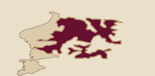
Cuesta Basáltica takes its shape from basaltic lava flows that extend from southern Brazil toward the Río Negro region. A large inclined slab descends toward the Uruguay River. Its eastern side is a steep escarpment, while the western surface slopes more gently. In eastern Artigas, basalt-derived soils are commonly just 0 to 15 cm deep. Erosion can remove the humus cover and expose the basalt beneath. Vegetation on this shallow ground is sparse and develops in winter. Shallow basalt and the local climate have made pasture difficult in parts of Artigas, where the landscape has traditionally been associated with sheep farming.
1 named area
Inside the region
Explore the wine-growing areas of Cuesta Basáltica.